Research Project OASES

OASES – Development and Demonstration of a Sustainable Open Access AU-EU Ecosystem for Energy System Modelling

Energy system modelling is the basis for the development and integration of renewable energy (RE) at local, national, regional, continental, and global levels. The resulting energy scenarios are crucial for understanding the contexts in which technologies and energy solutions need to be developed and contribute to being able to optimise future energy systems.

In the field of energy system modelling, there is a lack of holistic approaches that link all steps from the generation of RE input data, potential analysis, RE distribution, time series generation to system models. The required input data are the interfaces to the energy system model in terms of the spatial distribution of renewable energies, considering existing plants, potential areas and resource assessment, as well as the time series generation based on these.

The overall objective of the project is to develop and demonstrate a sustainable AU-EU ecosystem for energy system modelling based on open-source software and freely available data.

Fraunhofer IEE is responsible for the overall coordination of the project and is also researching the distribution of renewable energies under various boundary conditions.

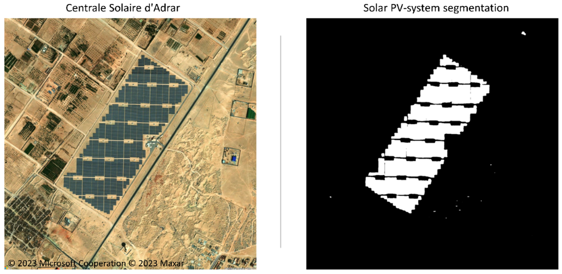
Figure 1: Scope and simplified illustration of the tasks performed in the OASES project.

Work Package 2: How can renewable energy systems be recognized from satellite images?

Machine learning methods, especially from the field of deep learning, can be used to automatically extract information from images such as aerial and satellite images. To do this, models are specifically trained for these tasks. For the detection of PV systems in various drone, aerial, and satellite images, a comprehensive model was trained specifically for this project. The description of the method and the final model have been published for free use.

How can a user without programming knowledge use the models?

For this purpose, the open-source QGIS plugin "Deepness: Deep Neural Remote Sensing," developed by the PUT Vision Lab (Computer Vision at Poznan University of Technology), can be used. It offers an intuitive interface for applying image recognition, object regression, and semantic segmentation in the domain of remote sensing. The plugin has been enhanced with a model developed in the project for the detection of PV systems. A deep learning-based model for the segmentation of PV systems in various resolution aerial and satellite images, jointly developed by the Department of Energy Management and Operation of Electrical Networks, the Fraunhofer IEE, and the Council for Scientific and Industrial Research (CSIR) from South Africa, has been integrated so that users can apply it directly to any location on the globe without further programming knowledge.

Case study for the final segmentation model in Algeria

Figure 2: Solar PV-system segmentation on Centrale Solaire d'Adrar.

We will now use the application in turn for various case study regions in the project. In Figure 2 you can see the very first test for a part of the local case study area in Algeria. Here, the final segmentation model was applied to the Centrale Solaire d'Adrar.

The image demonstrates how the application separates the PV-system from its surroundings. These results can now also be used as a basis for estimating the capacity. Furthermore, there are plans to extend the application to larger areas in various case study areas in Algeria, South Africa, and Egypt.


Work Package 3: How can weather data be processed for energy
system modelling?

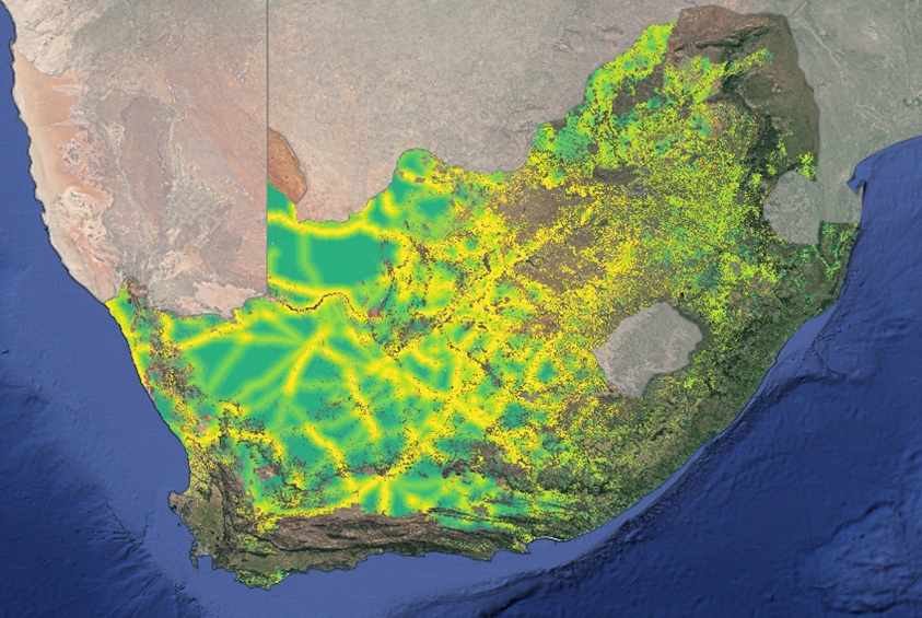
Figure 3: Evaluated multi-criteria potential analysis for pv-plants in South Africa.

To model renewable energy systems effectively, weather data must be processed to provide detailed and accurate information about renewable energy sources (RES) like wind and solar power. This involves utilizing publicly available datasets such as satellite and meteorological data and employing open-source tools for data processing. The data undergoes spatial downscaling to convert coarse-resolution climate data into high-resolution data (1km x 1km), and temporal downscaling to transform daily or monthly data into hourly time series.

Additionally, site suitability analysis is performed by assessing technical feasibility and environmental criteria and integrating these factors to identify optimal locations for renewable energy installations. The methods are initially tested using data from specific locations, such as South Africa, and then applied to other regions to ensure robustness.

Finally, the data, methods, and tools are made publicly available for broader use and validation, facilitating accurate assessment, and planning for renewable energy integration.

Work Package 4: How can the impact of variable power generation be analyzed in future energy systems?

The IRENA FlexTool is a model used to understand how variable power generation will affect future energy systems. It helps to plan both the expansion of energy capacity and the day-to-day operations of these systems.  


How can new users effectively utilize the IRENA FlexTool for scenario analysis?

The project will develop workflows, along with online documentation, for different spatial scales (local, national, regional, and continental). These workflows will feature user-friendly interfaces to help new users understand and meet data requirements and conduct meaningful scenario analyses using the data sources and modeling capabilities of the IRENA FlexTool. Finally, these workflows and documentation will be tested with project partners who are not familiar with the IRENA FlexTool.

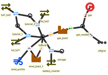
Figure 4: Entity graph of simple energy system model in IRENA FlexTool.

LEAP-RE Newsletter Beiträge

23. Februar 2024

OASES: Solar
photovoltaic system
segmentation research results published

07. Dezember 2023

OASES: Downscaling Climate Data to Upscale Climate Action

23. März 2023

OASES : Latest achievments and progress

Funding